BIG
SUR & MONTEREY COUNTY SUDDEN OAK
DEATH MONITORING
Monterey County is experiencing the Sudden Oak Death, known
as "SOD" in the oak wood communities.
SOD
infestation has been officially confirmed in Monterey County.
So far, dead and dying oaks are found, particularly, in
one of the most beautiful coastal zone -- the famous "Big
Sur" area. There is also one confirmed case in Manzanita
Park in North Monterey County.
In
Monterey County, the focus of attention now is in the "Big
Sur" area. Some hikers, campers and travellers, as
well as the biologists reported that the dead oak trees
are found as far north as Andrew Morella State Park along
Highway 1; in the "Julia Pfeiffer State Park";
and in the south beyond the Park along Highway 1. Generally,
the SOD infestation seems to be limitted to the coastal,
and concentrated in the vicinity of Big Sur. But, no one
knows exactly how far SOD has been widely spread inland.
Multi-agencies and local communities had gathered in Big
Sur, and expressed their concerns. No policy, no official
actions have been taken place, as far as Big Sur SOD is
concerned. In Monterey County, no agency has been given
authority to take charge of taking action (on monitoring,
prevention, education and outreach). There's no funds or
staff allocated to deal with SOD in Monterey County for
the time being. However, The Monterey County Ag. Commissioner's
Office, and the UCCE in Salinas are dealing with SOD issues
by responding to concerns, questions and reports of suspected
SOD cases.
Learning
SOD of Big Sur
Some students and staff with Cal State University-Monterey
Bay have made initial surveys of SOD in Monterey County.
Marie
Corwin, a graduating Earth Systems Science & Policy (ESSP)
student at CSUMB conducted a research survey for her "Capstone",
a senior thesis project -- "Sudden Oak Death impact on
local ecosystem". Assisted by CSUMB-Spatial Information
Visualzation & Analysis (SIVA) Resources Center, Marie
collected GPS locations of 206 coastal live oaks in Big Sur
Pfeiffer State Park campsite 185-218. Her stats shows that
48% of trees GPSed were infested with SOD. (See map: red =
healthy; yellow = infested)
Marie
emphasized the need for monitoring of the health and spread
of SOD infestation. She called for establishment of an education
program for the campers, etc. Currently, the Park has no policy
regarding SOD, thus there is a need to educate campers, vistors,
etc. about SOD and prevention of further spreading because
"contact" is one impartant mechanism for spreading
of SOD.
SIVA's
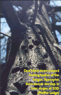
Reconnaissance of SOD around Big Sur Pfeiffer Lodge
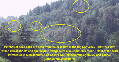
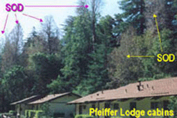
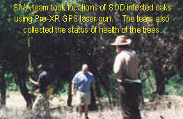
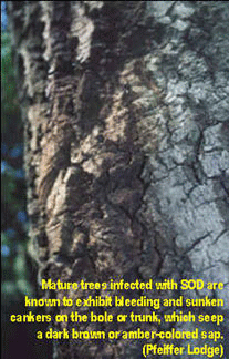
Mapping
SOD Spatial Distribution 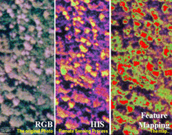
The CSUMB-SIVA Resources Center occasionally collected satellite
imageries such as Landsat 7 ETM covering Big Sur area. Based
on the experience that SIVA has had with "Mapping of
Pitch Canker Infestation in Monterey County: Monitoring, Education
& Outreach Project" SIVA's realized that 60-meter
spatial resolution of the Landsat image wouldn't be of much
use in identifying SOD. Therefore, SIVA managed to collect
a special collection of two natural color aerial photos (taken
from 12,000 feet altitude) in March. During the spring semester,
Adrian Rocha, a CSUMB-Advanced Remote Sensing student, tested
some remote sensing techniques for his class project,in an
attempt to identify the spatial distribution of SOD in the
Lodge area.
CSUMB-SIVA
is willing and capable to assist the Community in monitoring
SOD!
SIVA's reconnaissance of SOD infected trees in Big Sur Pfeiffer
State Park, and mapping practice have demonstrated that:
- SIVA
students and staff are capable of collecting health, symptoms
and characteristics of SOD in consistant with ongoing systems
established by University of California (Cooperative Extension);
- SIVA
is capable of using appropriate GPS devices for digitally
locating trees (GPS is used for ground-truthing of the outcome
from remote sensing analysis);
SIVA has been using remote sensing techniques that are applicable
to map SOD spatial distribution;
- SIVA
has been evaluating different types of imageries to find
one that would allow maximum accuracy in identifying the
interested features such as SOD oaks;
- SIVA
has experience with developing monitoring tool which would
allow monitoring the spatial distribution, and the spread
of SOD over time;
- SIVA
have been providing assistance in developing and maintaining
databases for the community programs such as pitch canker
database, and Centrat Coast Joint-Data Committee database;
SIVA can provide assistance in conducting further spatial
analyses in response to communities' needs.
Obviously, there are a lot of work needed to be done about
SOD in Monterey County. Monitoring and implementation of an
education and outreach program are essential tasks in the
attempt to prevent spreading of SOD within and outside of
the County.
The
outcome of this effort will be rewarding:
- Addressing
the concern of possibility of loosing oak species as an
integral part of California's diverse ecosystems;
- Observing
forest communities on a large scale at regular intervals
would be an invaluable resource in tracking the increase
or decrease of SOD infestation;
- Preventing
further spread of SOD phytophthora (especially to be addressed
to Park visitors).
Meanwhile,
SIVA is hoping that some Federal, State, and County (agencies),
and/or non-profit organizations might be able to make grants
and funds available to accomplish (a) acquisition of appropriate
imageries, (b) training for data collection, (c) GPSing, (d)
database, (e) image prosessing and analyses, and (f) dissemination
of information.
SIVA
is looking forward to jointly work with local and state agencies/organizations
responsible and/or charged to address the SOD issues.
Aknowledgement
& Sources of inormation on SOD
Report made by (Contact Person): U Win, Ph.D., CSUMB-SIVA
Research Associate (831-449-1182)
Information provided by: Marie Corwin and Adrian Rocha (CSUMB-ESSP
students); David Rosenow (SIVA-Technical Assistant); Brad
Oliver (Monterey County Ag. Commissioner's Office Biologist)
Other
sources of information on SOD: