MAPPING
OF POTENTIAL
GLASSY-WINGED SHARPSHOOTER
HABITATS: A PILOT PROJECT
 Project
Team:
-
Bay Area Shared Information Consortium (BASIC)
-
Spatial-Information
Visualization & Analysis (SIVA) Resources Center of
California State University at Monterey Bay (CSUMB)
-
Monterey
County Agricultural Commissioner's Office (MCACO)
During
the year 2000, there were approximately 46,200 acres of wine
grapes in Monterey County. According to Gomgerg, Fredrikson
& Associates, Wine Industry Consultants (April 2001),
total (grape and wine) industry revenues topped \$384 million
in the same year. Since the glassy-winged sharpshooter (GWSS)
was found to be a vector spreading the deadly Pierce's disease
(PD) in Temecula in southern California, Monterey County with
has taken the threat of GWSS invasion into the County very
seriously. As a result, in addition to the survey, trapping
and intensive inspection of nurseries, and other quarantine
activities, the Monterey County Agricultural Commissioner's
Office (MCACO) has taken an aggressive, proactive action -
developing a (digital) map showing the locations of potential
habitats of GWSS. On the first day of March 2001, the MCACO
entered into an agreement with the Bay Area Shared Information
Consortium (BASIC) which agreed to support the mapping of
potential GWSS habitats in a pilot project area within the
Salinas Valley. BASIC is a California registered 501 (c) (3)
corporation (a non-profit organization).
The
mapping effort was funded by BASIC under the ongoing National
Aeronautics and Space Administration's (NASA) Earth Science
Information Partner (ESIP) program, cooperative agreement
NCC5-317, in conjunction with the ongoing NASA-VINTAGE project.
The Spatial-Information Visualization & Analysis (SIVA)
Resources Center of California State University at Monterey
Bay (CSUMB) provided technical assistance in developing a
monitoring and planning tool using remote sensing (RS), Geographic
Information Systems (GIS), and image processing (IP) technologies.
Various in-kind services were provided by the MCACO. Local
communities such as Monterey County Vintners and Growers Association,
the Monterey County Farm Bureau, and the Central Coast Pierce's
Disease Task Force supported this effort.
Pilot
Project Area
The
northern part of mid-Salinas Valley was selected for the site
of the pilot project area. It extends the valley floor and
the foothills from south of Chualar down (south) to Gloria-Camphora
Road located south of the Soledad State Correctional Facility.
The City of Gonzales and the Soledad State Correctional Facility
lie within the pilot project area. It also is the northern
most area where vineyards are planted in the Salinas Valley.
Technically,
the pilot project boundary was demarcated along the boundaries
of the digital color infrared (DCIR) image frame provided
by the NASA Ames. It was discovered that the ground coverage
of some vineyards has extended beyond the western boundary
of the pilot project area reaching the ridgeline of Sierra
de Salinas ranges.
Overview
of GWSS and the spread of Pierce's Disease (PD)
The
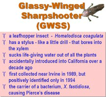
GWSS is a leafhopper insect that has a stylus - like a little
drill - that bores into the xylem of the plant. With this
unique apparatus, the insect can transmit lethal diseases
into the wood portion of plants and trees. With this stylus,
it also sucks life-giving water out of all the plants it feeds
on. Each adult GWSS sucks out 200 to 300 times its body weight
in water every day. This is the equivalent of an adult human
drinking 4,300 gallons of water per day. According to the
University of California (UC) Agriculture and Natural Resources
Department, GWSS (Homalodisca coagulata), was accidentally
introduced into California over a decade ago. It was first
collected near Irvine in 1989, but positively identified only
in 1994. GWSS is the carrier of a bacterium, X. fastidiosa,
causing Pierce's disease to grapevines and many other food
crops and ornamentals. X. fastidiosa is responsible for a
new oak leaf scorch disease being found in the East Coast.
GWSS has robust mouthparts and can feed on older wood. When
it feeds on wood at the base of canes and on older stems the
rate of spread of X. fastidiosa appears to increase from vine
to vine. Systemic infection is further promoted by placing
the bacterium in closer proximity to the xylem.
Since
the early 1990s, the glassy-winged sharpshooter has been seen
in high numbers in citrus orchards along the coast of southern
California. It spread further inland, and locally abundant
in Riverside and San Diego Counties. In 1997, the outbreak
of PD in Temecula, Riverside County, was first detected. The
following year the symptoms of the disease were visible in
only a few localized areas. By summer 1999 hundreds of acres
of vines were dead. In 1998 and 1999, high populations on
citrus and adjacent vineyards were seen in southern Kern County.
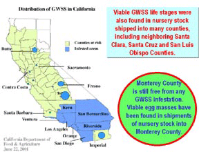
As of today, the GWSS infested areas include the entire counties
of Los Angeles, Orange, Riverside, San Bernardino, San Diego,
Ventura, and portions of Butte, Contra Costa, Fresno, Kern,
Imperial, Sacramento, Santa Barbara, and Tulare Counties.
Viable GWSS life stages were also found in nursery stock shipped
into many counties, including neighboring Santa Clara, Santa
Cruz and San Luis Obispo Counties. Santa Clara County is eradicating
an infestation in the southern part of the county. Monterey
County is still free from any GWSS infestation. Viable egg
masses have been found in shipments of nursery stock into
Monterey County.
 Hewitt
et al. (1946) documented that grasses in pasture or weedy
alfalfa harbored the PD vectors in San Joaquin Valley. Purcell
A.H. (1975) confirmed that the riparian areas were the habitats
of primary PD vector -- blue-green sharpshooter, in California
northern coastal region, however, vineyards located 400-600
away from riparian areas were found not affected by PD.
GWSS
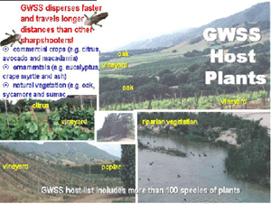
is a serious threat to California vineyards because it disperses
faster and travels longer distances than other sharpshooters.
GWSS lives on a wide variety of plants in Southern California
including commercial crops (e.g., citrus, avocado and macadamia),
ornamentals (e.g., eucalyptus, crape myrtle and ash), and
natural vegetation, including oak, sycamore and sumac. The
UC scientists noted that GWSS' ability to feed on dormant
trees and vines during winter months is unprecedented for
California sharpshooters, and it likely can reproduce on an
even wider variety of cultivated plants and natural vegetation
than is currently documented. The GWSS host list includes
more than 100 species of plants including commercial crops
such as almonds, citrus, peaches, plums, alfalfa and many
ornamental plants produced by the state's commercial nursery
industry. (See Appendix 1: Host Plants) The scientists also
believe GWSS has the potential to increase both the incidence
and severity of Pierce's disease in California because it
can utilize more breeding habitats and plant hosts than native
PD vectors (opportunistic behavior).
GWSS
has been found in citrus and avocado groves, and on woody
ornamentals. Oleander leaf scorch has become a serious problem
for the California Department of Transportation (CalTrans).
The sharpshooter threatens native plants, shrubs and trees.
It has been documented GWSS feeding on over 70 species of
plants in 35 different plant families and is active throughout
the year. Favorite residential host plants for the sharpshooter
include ash, bougainvillea, camellia, citrus, crape myrtle,
eucalyptus, loquat, magnolia, mulberry, oak, privet, umbrella
tree, apple, most stone fruits, blackberry, Chinese elm, oleander,
philodendron, pine, sycamore, trumpet flower, wisteria, willow
and yucca. It reproduces on Eucalyptus and coast live oaks
in southern California.
A
study conducted by Perring, TM, et al. (2000) has proved that
proximity to citrus has influenced the incidence and severity
of PD. In other words, higher disease severity is found closest
to the citrus, and lower severity further from citrus. In
the Temecula Valley, vineyards located within 1,000' (38%)
and 2,000' (72%) of citrus groves allowed the rapid dissemination
of PD throughout the Valley. They suggested that "Grape
growers throughout the state should be particularly watchful
of vineyards near citrus groves. Similarly, other areas containing
non-citrus GWSS host plants should be monitored for GWSS,
and vineyard borders near these areas should be surveyed for
PD."
The
effort to map the potential habitat areas for glassy-winged
sharpshooters in the Pilot Project Area aims to produce a
monitoring and planning tool for the MCACO that would apply
remote sensing (RS), Geographic Information Systems (GIS),
and image processing (IP) technologies. The pilot project
effort has established methodologies to achieve the objectives
of identifying and mapping existing vineyards, and high risk
areas for being invaded by GWSS. As the objectives are achieved,
the effort has reached the state of readiness to conduct a
(Salinas) valley-wide mapping of vineyards and potential GWSS
habitat areas in the near future.
Methodology
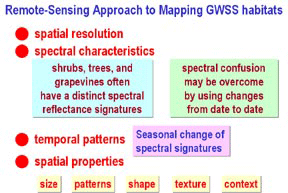 This
pilot project focused on the feasibility of using remotely-sensed
image data, image processing, and geospatial information system
(GIS) technology to map potential GWSS habitats. In general,
GWSS potential habitats are perennial vegetation such as shrubs,
trees, and grapevines. Thus, the success of any remote-sensing
approach to mapping GWSS habitats depends on the spatial resolution
and spectral characteristics of the associated imagery. Since
shrubs, trees, and grapevines often have a distinct spectral
reflectance signatures compared to bare soil, herbaceous vegetation
(crops, grass, pastures), open water and a host of manmade
materials (roads, roofs, buildings), multispectral remote
sensing can be a successful way to map GWSS potential habitats.
Row crops and herbaceous crops of low to medium cover may
have spectral signatures similar to that of shrubs, trees,
and grapevines. If remotely-sensed data are available for
a number of dates during a growing season, the spectral confusion
may be overcome by using changes from date to date. GWSS potential
habitats have spectral signatures that change much shower
than the spectral signatures of herbaceous crops, especially
short-season crops or crops that are mowed often during the
growing season. Longer season herbaceous crops or herbaceous
crops that are perennial have spectral signatures that are
distinctly different from shrubs, trees, and grapevines. In
addition to spectral and temporal patterns, a GWSS potential
habitat mapper can take advantage of spatial properties such
as size (of agricultural fields and individual plants such
as trees), patterns (row crops versus random placement of
plants), shape (agricultural shapes or natural shapes), texture
(smooth herbaceous crops versus "rough looking"
shrubs and trees), and context (e.g., urban environments contain
numerous shrubs and trees that may not be identifiable in
spectral data due to mixtures with non-vegetative materials).
All of these considerations were the subject of this pilot
project.
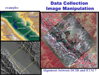
Data
Collection and Image Manipulation
A
variety of remotely sensed data were used in this effort.
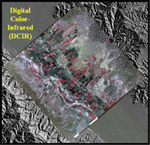 One
was a set of digital color-infrared (DCIR) imagery of the
pilot project area that was received from the NASA Ames Research
Center (ARC). ARC produced the DCIR by scanning aerial 9-inch
color-infrared (CIR) photos taken from the NASA ER-2 high-altitude
aircraft (about 65,000 ft). The ground spacing distance (GSD)
of the DCIR is 1-meter between neighboring pixels. While these
DCIR data were high resolution, they lacked spectral purity
due to the use of CIR film, which blurs the differences among
green light (GL), red light (RL), and near infrared (NIR).
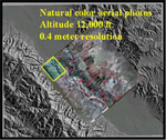 SIVA
also purchased four natural-color (NC) aerial photos covering
the northwestern section of the pilot project area. These
NC photos were taken from an altitude of 12,000 feet. After
being scanned, the is 0.4-meter per pixel.
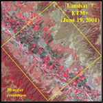 To analyze the temporal changes in the land cover in the pilot
project area, the sponsor, BASIC, purchased a scene of Landsat
7 ETM+ (Enhanced Thematic Mapper Plus) dated June 19, 2001,
which is relatively comparable to the same scene of Landsat
7 ETM+ taken on June 30, 1999. The GSD of Landsat images are
30-meter and 28.5-meter respectively. The Instantaneous Field
of View (IFOV) for ETM+ data is 30-m by 30-m (except for the
panchromatic Band 8, which has an IFOV of 15-m by 15-m).
USGS 7.5-minute (1:24,000) Digital Elevation Model (DEM) datasets
were also obtained having a GSD of 30 meters.
For the cross-referencing purposes in the interpretation of
the remotely sensed imageries, a few GIS datasets were obtained
from the County of Monterey. They include:
-
Roads & High ways line networks (source: Monterey
County Water Resources)
- Ranch
map boundary polygons (source: Monterey County Agricultural
Commissioner's Office)
- City
limits boundary polygons (source: Monterey County Water
Resources)
- 1999
Land use polygons (source: Monterey County Water Resources)
Determining
Potential GWSS Host Plants for Identification
As
a group effort, the MCACO biologists and staff, a UCCE agent,
who specialized in PD and GWSS, and the SIVA staff collectively
selected the following GWSS host plants and their locations
as features to be identified by using remote sensing methods:
vineyards, riparian area, citrus orchards, oaks, eucalyptus,
avocados, cactus, and ornamental vegetation.
Image
Processing, Analysis and Ground-truthing
 SIVA
used ESRI's ArcView GIS program to access available GIS coverages
maintained by the County of Monterey. These GIS coverages
were then imported into MicroImages' TNTmips program for geospatial
analysis. TNTmips was also used for handling all remotely-sensed
image data.
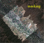
 Using the TNTmips Feature Mapping technique, areas above and
beyond the cultivated areas were masked to exclude them from
the analysis of the image. Feature Mapping is a supervised
classification approach (based on simple range tests within
each spectral band) that the analyst could override by what
he or she sees on the display screen (i.e., based on spatial
properties of size, shape, pattern, texture, and context).
The Landsat 7 ETM+ (June 19, 2001) image was enhanced calibrated
and used in Feature Mapping to locate the vineyards. Due to
the low resolution (30-meter) with the Landsat 7 ETM+ image,
it was required to crosscheck the ETM+ results with the results
from the DCIR image, aerial NC photos and land cover GIS data
from the County of Monterey.
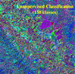
A
different approach to spectral analysis was unsupervised classification
using a clustering algorithm such as ISODATA (in the TNTmips
software). Using only the spectral signatures, unsupervised
classification was conducted to produce 150 spectrally-different
classes. Following this, the TNTmips Feature Mapping process,
which is heavily supervised by the analyst, was used to identify
spectral clusters/classes associated with vineyards and other
potential GWSS host plants.
Due
to the low ETM+ resolution, it is difficult to distinguish
between early-stage vineyards (having grassy ground cover)
and grasslands based off of the ETM+ image. The same situation
occurred between mature (full-foliated) vineyards and other
mature crops such as cactus, citrus orchards and row crops.
The DCIR data with their high-resolution 1-meter resolution
allowed the analyst to distinguish among different types of
crop (plants) by visually identifying row patterns, and width
of the plant-beds. Cross-referencing with other data such
as the County of Monterey Land Cover was useful in the verification
of types of crop (plant). Citrus and avocado allowed detecting
different spectral signatures. The DCIR, County Roads, County
Land Cover, and Ranch GIS information were used in verification
and cross-checking of the sites.
Results
As
a result, ground-truthing was essential for the verification
of what was identified to be on the image and what was really
on the ground. Assisted by the MCACO field staff, ground-truthing
work was conducted a few times during the summer of 2001.
At the beginning of the project, a few points (locations)
of the features (host plants) were mapped by a Trimble Global
Positioning System (GPS) unit. These GPS locations were displayed
over the imagery under spectral analysis with the aid of the
TNTmips GIS program. The points indicate the locations of
different types of plants. This approach was helpful in identifying
and distinguishing the spectral signatures of one type of
plant to another within the same crop or land-cover class.
After preliminary identification of the locations of the host
plants was completed, another round of ground-truthing was
conducted to validate the GWSS potential habitat mapping units.
Ground-truthing helped in differentiating the vineyards in
early stage, as well as vineyards in initial stage which spectral
signature was similar to those of bare soils. Ground-truthing
also has allowed us to distinguish among tree features such
as eucalyptus, oak and other trees.
Areas
of riparian vegetation are located within the river channel,
ditches, and ponds. For this mapping project, the riparian
zone as defined by the County of Monterey was assumed to be
valid. Ornamental plants, another GWSS potential habitat,
are mostly used for the landscaping in the urbanized areas.
The locations of ornamental plants were assumed to be within
general city-limits (urban-boundaries). The City of Gonzales,
the property Soledad State Prison, and a property owned by
the City of Soledad are the areas where ornamental host plants
are considered to be located.
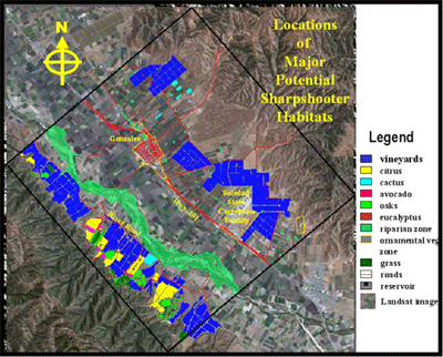
The
map above shows the spatial distribution of vineyards and
other major potential sharpshooter habitats. The proximity
of vineyards to the other potential sharpshooter habits can
be visually identified. In other words, it is easy to identify
which vineyards are most vulnerable should there be a sharpshooter
invasion. For the monitoring and planning purpose, the map
allows one to select strategic sites where the (GWSS insect)
traps should be placed.
By
overlaying the "Ranch Map" GIS data (layer) the
name of each ranch can be identified. It is important to note
that the geopositional accuracy of ranch boundaries in the
available GIS data is very low, however, it is useful in identifying
the name of the ranch and approximate location of the ranch,
and plants that have been cultivated on it.